

Local Sponsors
-
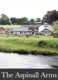
The Aspinall Arms
Mitton Rd, Mitton, Clitheroe, Lancashire, BB7 9PQ
The Aspinall Arms is found right in the heart of the Ribble Valley, and sits on the banks of the river overlooking the medieval All Hallows church and the 14th century Great Mitton Hall on the raised bluff opposite. With terraced and landscaped gardens outside, and flagged floors and open fires inside, it's just the pub for walkers, cyclists and anglers to mingle and dine alongside the friendly locals.
More information
Many thanks to The Aspinall Arms for facilitating this camera's location and for capitally funding its installation. The Mitton Bridge serves as a crossing point for the B6246 road over the River Ribble. Constructed from sandstone, the bridge features three segmental arches adorned with rounded cutwaters. Its design includes a sturdy parapet, a string course, and weathered coping. Notably, there is an inscription located on the southern parapet, adding to its historical significance. The River Ribble flows through North Yorkshire and Lancashire, originating near the Ribblehead Viaduct in North Yorkshire. It stands out as one of the few rivers that begins in the Yorkshire Dales and flows westwards toward the Irish Sea. The presence of Neolithic to Saxon artifacts discovered along the River Ribble during the development of the Preston Docks suggests that humans have inhabited the area for a significant period. It is worth noting that the landscape and coastline of the River Ribble have undergone changes over time, with land reclamation and sedimentation leading to alterations in its appearance. In Roman times, the Ribble was likely known as the Belisama, a name that possibly influenced the naming of Samlesbury. Ptolemy's 'Belisama aest.' appears to refer to the estuary of the Ribble. The Roman fort of Bremetennacum stood as a guardian of a river crossing at Ribchester, while remnants of another Roman site were discovered in Walton-le-Dale during the mid-19th century. Notable archaeological finds include the medieval silver Mitton Hoard, discovered near the confluence of the River Ribble and the River Hodder in 2009, and the Cuerdale Hoard, the largest Viking silver hoard outside Russia, found in 1840 on the southern bank of the river bend near Cuerdale, close to Preston. At one time, the Ribble marked the northernmost boundary of the ancient kingdom of Mercia. During the era of the Domesday Book, the river formed the northern limit of a region called "Inter Ripam et Mersam," which was included in the Domesday records for Cheshire, although it was likely not formally part of the county. Following his defeat in the Battle of Hexham in 1464 during the Wars of the Roses, King Henry VI sought refuge in various houses belonging to his supporters. Approximately one year later, he found himself at Waddington Hall in Waddington. On July 13, 1465, a contingent of Yorkists, including the brother of the property owner, arrived at the hall to apprehend him. Henry managed to escape into nearby woods, but was captured shortly after crossing the river at the old stepping stones located at Brungerley. Additionally, a strategically positioned Farson streaming webcam aids in monitoring water levels and fishing conditions along this stretch of the River Ribble.